![]() > Pisan Projects >Improvement of signage
> Pisan Projects >Improvement of signage
MARINA PORT D´ARO. Second Phase
Partial and Special Urban Planning Plan
Sector: Ports/Hydraulic works
Servicios: Urban management, Urban planning
- Partial Urban Development Plan SUD 3 for the expansion of Port d'Aro.
- Special Urban Development Plan for the expansion of Port d'Aro
- Plot Division Project
The urban partial plan SUD 3 for the expansion of Port d’Aro, definitively approved on July 2nd, 2014, by the municipal council of Castell-Platja d’Aro, develops the delimited discontinuous area of urbanizable land, following the prescriptions established by the POUM of Castell-Platja d’Aro for this sector. Simultaneously with this Urban Partial Plan, a Special Plan is being drafted which, in accordance with the provisions of the Ports of Catalonia Law and following the prescriptions of the POUM itself, adjusts the dimensions and formalization of the water sheet of the expanded marina of the existing Port d’Aro. Among the objectives of the urban partial plan, the following stand out:
- Desenvolupar a la zona nord-oest del sector una zona hotelera, amb una edificació de gran qualitat arquitectònica, enfront d’un espai lliure públic fins al moll de la nova marina.
- Creation of a reserved area for amenities in the northern part of the sector, adjacent to the hotel, to provide services specifically to the sector and also to the overall population of the municipality.
- Creation of a large public leisure area facing the sea with high environmental quality, and landscaping of this area to create a large Mediterranean pine grove along the waterfront, adjacent to the existing pine grove between the parcels designated for private single-family homes and the seafront promenade and beach.
- Providing the area with a reserved area for high-capacity parking (600 spaces), independent of the reserved area planned for housing use, to serve the entire activity generated by the development of the sector.
- Creation of a footbridge over the Ridaura River to facilitate communication between the two riverbanks. The footbridge will have the necessary features to provide high-quality accessibility, including stairs and an elevator if needed, and will connect the two riverbanks at the busiest point, which includes the commercial, hotel, and urban garden areas of the SUD 3 Port d’Aro expansion sector.
- To establish a connection between the two main pedestrian avenues of Platja d’Aro, namely Avenida de S’Agaró and the Paseo Marítimo, through a riverside promenade along the northern perimeter bordering the Ridaura River, in order to provide continuity to the greenway until reaching the sea. This promenade will feature tree-lined and landscaped areas, along with paved and recreational zones.
- The main residential areas will be located on both sides of the future canal, between the canal and the streets Rec del Molí, Xaloc, and Rosa dels Vents, the newly created river promenade, and the area closest to the new pine forest expansion of Parque de los Enamorados, in order to take advantage of the entire perimeter of the canal for housing and thus strengthen the relationship between the buildings and the marina canals within the framework of a maritime-terrestrial urbanization.
- The commercial area will be located close to Avenida de s’Agaró, and adjacent to the plaza at the end of the canal, taking advantage of the creation of a large parking area.
- The perimeter road network will serve as a support network for mobility within the sector and in general for this part of the municipality.
- A subterranean passage underneath the canal will be constructed to restore the communication between Avenida Verona-Terol and the coastal strip, which is currently interrupted by the canal. The passage will accommodate both pedestrians and vehicles, with a minimum clearance of 3.50 meters, avoiding the use of “drawbridges” that impede uninterrupted boat traffic to access the marina.
- A road network will be implemented with a main road on the northern side that will encircle the area, connecting with the existing road leading to the Nautical Club and the newly created underpass in Avenida Verona Terol beneath the marina canal, providing seamless connectivity.
- The plot of 3,500 m² adjacent to Tramuntana Street in the discontiguous area will be designated for the construction of affordable housing units for public protection.
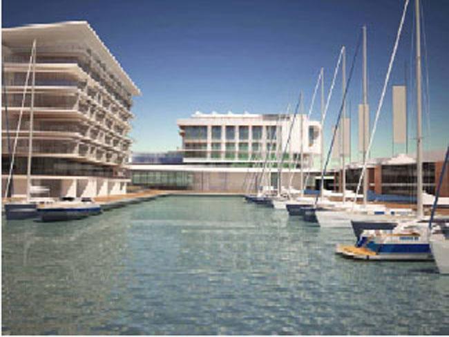
TheSpecial Urban Planning for the Expansion of Port d’Aro. Definitively approved by the Territorial Urban Planning Commission of Girona in the session held on July 22, 2014. Establishes the shape of the water sheet of the new marina expansion of Port d’Aro in a way that maintains a biunivocal relationship with the surrounding buildings. The surrounding perimeter forms a corridor that belongs to it, which is the space of transit servitude, in such a way that it glides along the edge of the water, respecting the buildings and making this relationship the main characteristic of the new marina of Port d’Aro. The water surface of the new marina has an area of 32,794.50 m² and a total of 272 moorings for vessels with lengths between 10 and 18 meters. The land area of the marina, between the nautical service strip and the port services, has an area of 8,943.22 m². In the bend formed by the access channel to the existing marina and the one that leads to the harbor, a small port is formed, which we call the “small harbor”. Over this basin is the surveillance and services building. In this small harbor, around which housing units are grouped, there are no vegetated areas, in contrast to the other buildings that always have recreational areas. This area is more densely populated, and the building typologies are designed to accommodate this density. At the end of this canal, there is a boat repair and maintenance area, which includes a service ramp and a travel lift for hauling out boats without keels for repairs or dry storage in a dry marina. The marina ends just in front of the building consisting of the equipment and hotel, with its terrace located at elevation +5, below which there are commercial premises that are intended to bring life to the final basin, the true central port of the marina. The storage spaces Pañoles provide service to boats through the traffic servitude area, while also helping to privatize the open space of the multi-family dwellings by being located on an elevated plane compared to the marina docks. The marina has a gravity-based water renewal system, allowing for easy water exchange, with water entering through the main entrance and a maximum draught of 3.50 meters. The SUD 3 Parcel Replotting Project for the expansion of Port d’Aro is drafted with the purpose of:
- The fair distribution of benefits and burdens of the urban planning among the interested parties.
- The regularization of the plots to adapt their configuration to the requirements of the urban planning.
- The situation regarding specific plots and areas suitable for building development, both those allocated to private owners and those that fall under the jurisdiction of the administering body in accordance with legally established land transfer obligations and development rights.
- The free transfer of land to the administering body for urban systems, in accordance with the provisions set forth in the urban planning.
- The determination of urbanization fees to be borne by the property owners and, as applicable, the administering body, as well as the payment methods, which may be in cash or in the form of developable land. The urbanization fees include both the cost of the urbanizing works as well as the compensations and economic compensations that may be necessary to ensure the principle of equitable distribution of benefits and burdens.
As it is a maritime-terrestrial urbanization, the subdivision project notes the connection of the adjacent moorings to the private residential use plots, i.e., the plots with residential development rights. There are two types of moorings that do not adjoin these plots: non-linked private use moorings and tariffed public use moorings.